Along Louisiana’s coast, restoration often begins with a local conversation at a feed store, a coffee shop, or on the marsh itself.
Since 1988, that practical starting point has defined Louisiana’s Coastal Vegetative Planting Program, a partnership among conservation districts, state agencies, federal technical partners and private landowners designed to stabilize eroding shorelines through native marsh planting in a state that has lost about 2,000 square miles of coastal wetlands during the past century.
Over more than three decades, that response to land loss has evolved into one of the country’s longest-running district-led coastal restoration efforts, helping protect fisheries, wildlife habitat, shoreline resilience and coastal livelihoods while supporting up to 40 linear miles of vegetative planting each year.
By the time Louisiana’s planting program took shape, the state’s coastal crisis had already reached an extraordinary scale. Marsh loss, shoreline recession and land subsidence were reshaping large portions of the region, forcing agencies and landowners to look for restoration methods that could work quickly. Even before the formal program emerged, agencies were experimenting with marsh revegetation, searching for practical ways to stabilize eroding shorelines under conditions that differed from many other coastal areas.
Joey Breaux, assistant commissioner for soil and water conservation and executive director of Louisiana’s State Soil and Water Conservation Commission, said those realities made vegetation especially attractive as a restoration tool.“
The coastal problem was complex because we were dealing with subsidence and shoreline recession simultaneously,” Breaux said. “Vegetation had a stabilizing effect that was more than a band-aid. It was a more integrated fix, more in tune with the natural lower estuary ecology.”
Traditional shoreline hardening methods remained useful in selected locations, but vegetation offered something different: a living system capable of slowing wave energy, trapping sediment and helping marsh edges recover naturally.
Initial plant selection was experimental. “It certainly had to prove itself first,” Breaux said. “We had only one cultivar suitable for that work at the time, so it was a big learning curve.”
That learning period helped define how the program grew. Initial demonstration efforts became test sites for methods later used more broadly, while giving landowners visible examples closer to home.
As early efforts produced results, Louisiana formalized the partnership in the early 1990s: the Coastal Protection and Restoration Authority (CPRA) provides funding, NRCS supplies technical support, the state Office of Soil and Water Conservation administers the program, and local conservation districts work directly with landowners.
For Breaux, that structure explains why the program has endured. Each role in this approach filled a distinct need — funding, practical guidance and trusted local delivery. “That’s the beauty of the whole program,” he said.
“You had the CPRA funding, you had NRCS handling the technical side, and you had local conservation districts that already knew how to work with landowners. That combination is what made it work.”
Greg Grandy, longtime coastal resources administrator for the CPRA, said the framework was intentional from the start, designed to give local relationships room to test ideas under real coastal conditions.
That structure could translate to other coastal states because many already have conservation districts, NRCS field offices and state agencies capable of coordinating pilot-scale restoration efforts before larger investments are made, with local collaboration helping test methods before scaling them more broadly.
In Louisiana, projects begin where erosion problems are first identified — on the ground, with landowners and conservation districts evaluating practical solutions together. Because the work is developed locally, design remains highly site-specific. Salinity, soil type, wave exposure and herbivore pressure all help determine whether planting is appropriate.
Species and spacing are matched to local conditions using marsh grasses and other native vegetation suited to shoreline exposure. Native stock developed through NRCS’s Golden Meadow Plant Materials Center has helped refine selections for Louisiana’s variable coastal conditions.
“Since projects are initially selected and designed on a local basis, the flexibility of the program encourages experimentation,” Grandy said. That approach has also allowed field methods to evolve over time.
“Sometimes bare-root propagules worked better than containerized plants,” Breaux said. “We thought the bigger the root ball, the quicker you’d get establishment, but project costs went up and results weren’t always better.”
Nutria guards, plant anchors and other field practices were also refined as results accumulated, showing which techniques added value and which did not.
Those practical lessons reinforced what Breaux said often shapes early conversations with property owners: immediate economic realities. “Paying massive taxes on land that doesn’t even exist anymore is the first one,” he said. “You want to stop the bleeding.”
That urgency often becomes cooperation once work begins, said Tim Allen, land manager for Apache Corporation and chairman of Lafourche-Terrebonne Soil and Water Conservation District.
“The very least landowners can do is provide local knowledge and historical expertise, logistical boat support, and staff time and horsepower to assist with the project,” Allen said. He added that visible success on one property often encourages neighboring landowners to try similar work nearby.
Grandy said smaller undertakings remain indispensable because they allow field experimentation before problems require more extensive intervention. These efforts “provide an opportunity for implementation and monitoring of innovative projects, the lessons of which can be applied at larger scales,” he said.
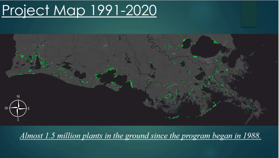
The total area planted in the Louisiana Coastal Vegetation Program coastwide to date is approximately 1,200 linear miles of vegetation. Image by Jeremy Rodriguez.
Over time, the pilot-scale approach has become one of the program’s most transferable strengths. In Louisiana’s broader coastal strategy, vegetative planting remains one necessary layer within larger coastal work. It often produces tested methods that broader restoration efforts later adopt. It also helps local conservation districts extend practical knowledge to private landowners who might otherwise never participate.
Even after decades in the program, Breaux still reacts personally when he sees a successful planting site holding shoreline.
“It’s just beauty. I love it,” Breaux said. “When I see a successful project, especially one out there on the edge in a high-energy area, there’s so much that happens because of that success — public safety, improved water quality, improved wildlife habitat and just a better quality of life for the people down there.”
In Louisiana, the practical lesson is clear: cost-effective restoration works best when local trust, technical support and long-term commitment reinforce one another. Built at the grassroots level with state and federal support, the program has allowed field-scale efforts to test methods
and demonstrate a working model for coastal restoration that other states could adapt.